Purva Trivante (Kensho Hills) Location

Purva Trivante sits about 1.8 km off the Sarjapur-Attibele Road, between Sarjapura town and Attibele, with Indus International School about 2.3 km away by road. The layout is at S. Medahalli in Anekal Taluk, south-east Bengaluru, close to the Karnataka-Tamil Nadu border and about 16.6 km by road from Hosur. It suits buyers who want plots near Sarjapura with schools, the town and the state highway close at hand, and who are comfortable driving to the metro and the larger IT hubs. For location reading, Purva Hallmark keeps the context local: commute anchors, school access, hospital reach, retail convenience, and last-mile movement decide whether the address works.

Every distance here is by road from the layout, as at 24 September 2026. Traffic on these roads changes with the hour, so the real test is to drive your own routes at the times you would travel.

Purva Trivante Address

Purva Trivante spreads across two neighbouring villages, S. Medahalli and Adigarakallahalli, in Sarjapura Hobli, Anekal Taluk.

Address detailPurva Trivante
VillagesS. Medahalli and Adigarakallahalli
Hobli and talukSarjapura Hobli, Anekal Taluk
District and PINBengaluru Urban 562125
Main road accessSarjapur-Attibele Road (SH-35), about 1.8 km by road
Road frontagean existing 12 m road along the northern edge
K-RERA registrationPRM/KA/RERA/1251/308/PR/210324/006719, registered as Purva Kensho Hills

You may also see the village spelt S. Medihalli, the spelling Puravankara uses. It is the same place, registered as S. Medahalli.

The layout fronts an existing 12 m road along its northern edge, shown on the approved plan as a proposed master-plan road. The internal roads, parks and clubhouse site are set out on the master plan; ask to see the entrance position on the ground when you visit.

For your lawyer, the survey numbers are Adigarakallahalli Sy. 110/1-4 and 120/1-3, and S. Medahalli Sy. 206/9, 206/10, 206/12, 207/1-7, 208/1-5, 209/1-5, 210/2, 211/1, 212/1-4 and 213/1. Match them against the schedule of your agreement for sale and against the K-RERA registration above.

Purva Trivante Road Connectivity

Purva Trivante reaches the wider city through the Sarjapur-Attibele Road (SH-35), an existing two-lane state highway about 1.8 km by road from the layout. Sarjapura town centre is about 4.5 km to the north by road, and Attibele about 8 km to the south-west, where the Hosur Road (NH-44) check post is about 8.7 km away.

From Purva Trivante toBy road
Sarjapur-Attibele Road (SH-35)about 1.8 km
STRR (NH-648) at Sarjapura - section under constructionabout 4.4 km
Sarjapura town centreabout 4.5 km
Attibele bus standabout 8.0 km
Attibele, NH-44 (Hosur Road) check postabout 8.7 km
Dommasandra Circleabout 9.0 km
Chandapuraabout 15.2 km
Hosur bus stand (Tamil Nadu)about 16.6 km
ORR-Sarjapur Road junction (Iblur)about 20.3 km
Kempegowda International Airportabout 57 km

The Satellite Town Ring Road (STRR, NH-648) section from Hoskote to the Tamil Nadu border runs through Sarjapura, about 4.4 km by road from the layout. It is under construction; completion targeted for November 2026. Until it opens, plan every journey on the roads in use today.

Kempegowda International Airport is about 57 km by road on roads open today, by way of Sarjapura, Varthur, Whitefield and Hoskote.
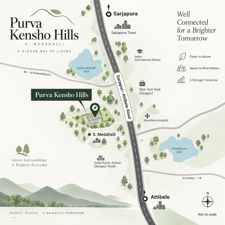
Purva Trivante location map at S. Medahalli off the Sarjapur-Attibele Road, between Sarjapura and Attibele
Indicative location map - Purva Trivante off the Sarjapur-Attibele Road, between Sarjapura and Attibele (not to scale).

Purva Trivante Metro and Rail Access

For metro travel, the closest station to Purva Trivante is Delta Electronics Bommasandra on the operational Yellow Line, about 18.4 km by road. The Yellow Line has been operational since August 2025, and Delta Electronics Bommasandra is its southern end.

Metro or rail linkStatus as at 24 September 2026By road
Delta Electronics Bommasandra metro (Yellow Line)operational since August 2025about 18.4 km
Biocon Hebbagodi metro (Yellow Line)operational since August 2025about 20.1 km
Electronic City metro (Yellow Line)operational since August 2025about 23.4 km
Yellow Line extension to Attibeleproposed - the state has approved preparation of a detailed project report; no sanction or opening date-
Sarjapura-Hebbal metro (Red Line)proposed - awaiting central government sanction; no opening date-
Carmelaram railway stationoperational, Bengaluru-Hosur lineabout 15.7 km
Heelalige railway stationoperational, Bengaluru-Hosur lineabout 17.3 km
Hosur railway stationoperational, Bengaluru-Hosur lineabout 18.7 km

The two proposed metro lines have no opening date, so no station distance is given for either; weigh the layout on the operational line at Bommasandra.

Carmelaram station on the Bengaluru-Hosur line is about 15.7 km by road, with Heelalige about 17.3 km and Hosur about 18.7 km. For buses, Sarjapura bus stand is about 4.5 km by road and Attibele bus stand about 8 km; ask on your visit which local services stop closer to S. Medahalli. At these distances, plan on a car or a cab for most daily trips today.

Schools near Purva Trivante

Purva Trivante puts Indus International School about 2.3 km away by road and Azim Premji University about 4.5 km, which makes it a natural shortlist entry for families looking at plots near Azim Premji University or the international schools around Sarjapura.

School or collegeBy road from Purva Trivante
Indus International Schoolabout 2.3 km
Azim Premji Universityabout 4.5 km
Harvest International School, Attibeleabout 6.2 km
ISME (International School of Management Excellence)about 8.3 km
Oakridge International Schoolabout 9.4 km
The International School Bangalore (TISB)about 10.5 km
Silver Oaks International Schoolabout 10.7 km
Inventure Academyabout 11.0 km
Greenwood High, Sarjapur Roadabout 11.5 km
GIG International Schoolabout 12.2 km
Delhi Public School Bangalore Eastabout 12.7 km

Beyond Indus and Azim Premji University, the schools on this list are between about 6.2 and 12.7 km by road, so for most families the school run will be a daily drive or a school bus. Ask each school whether its buses reach S. Medahalli before you choose a plot on the strength of it. Village and government schools nearer the layout are not listed here; ask about them locally.

Workplaces near Purva Trivante

Purva Trivante has a technology employer close by, with SABIC's India Technology Center about 3.4 km by road. The larger IT campuses and industrial areas sit between about 11.6 and 23.8 km away by road.

WorkplaceBy road from Purva Trivante
SABIC India Technology Centerabout 3.4 km
Attibele Industrial Areaabout 11.6 km
Wipro SEZ, Kodathi (Sarjapur Road)about 13.8 km
IndiQube The Foreabout 14.2 km
RGA Tech Parkabout 15.5 km
Bommasandra Industrial Areaabout 17.7 km
Wipro corporate office, Doddakannelliabout 17.7 km
Hosur IT Park (ELCOT IT SEZ, Viswanathapuram, Tamil Nadu)about 18.8 km
Electronic City (Infosys campus)about 23.8 km

If you will commute daily to Wipro SEZ at Kodathi, about 13.8 km, or to Electronic City, about 23.8 km, drive the route at your usual hour before you commit. Across the state border in Tamil Nadu, Hosur IT Park is about 18.8 km by road, much the same distance as the Bommasandra Industrial Area, about 17.7 km.

Want the Purva Trivante price list and plot availability as soon as Puravankara releases them, or a site visit to S. Medahalli? Ask the team directly.

Register Your Interest

Hospitals near Purva Trivante

Sarjapura town, about 4.4-5 km by road from Purva Trivante, has the Urban Primary Health Centre and Town Hospital. The Oxford Medical College Hospital, a teaching hospital, is about 10.8 km, and Narayana Health City about 17 km.

HospitalBy road from Purva Trivante
Sarjapura Urban Primary Health Centreabout 4.4 km
Town Hospital, Sarjapuraabout 5.0 km
The Oxford Medical College Hospitalabout 10.8 km
Sri Sai Hospitals, Yadavanahalliabout 11.4 km
Narayana Health City (Mazumdar Shaw Medical Center and Narayana Institute of Cardiac Sciences)about 17 km
Manipal Hospital Sarjapur Roadabout 19.6 km

Clinics nearer the layout are not listed here. Before you move in, drive the route to the hospital you would use in an emergency, and note the one you would use for specialist care.

Shopping and Lakes near Purva Trivante

Everyday shopping for Purva Trivante is in Sarjapura town, with DMart Sarjapura about 5 km by road; Natura Walk is about 7.7 km. Sarjapura Lake and Dommasandra Lake are both within about 10 km by road.

PlaceBy road from Purva Trivante
DMart Sarjapuraabout 5.0 km
Natura Walkabout 7.7 km
Sarjapura Lakeabout 5.7 km
Dommasandra Lakeabout 9.8 km

Closer to home, the layout's own 15 parks and open spaces, with a stroll path and nature walk, are set out on the amenities page.

Purva Trivante Location Trade-offs

Purva Trivante gives you land in a peri-urban setting between Sarjapura town and Attibele, with a school, a technology campus and the state highway all within about 3.4 km by road. These are the trade-offs to weigh.

  • The metro and the big IT hubs are a drive away. Delta Electronics Bommasandra is about 18.4 km by road, and the large IT campuses about 14 to 24 km.
  • The new ring road is not open yet. The STRR section through Sarjapura is under construction; completion targeted for November 2026.
  • The proposed metro lines have no dates. The Attibele extension and the Sarjapura-Hebbal line are both proposed, with no sanction or opening date for either.
  • The state highway is two-lane. SH-35 is an existing two-lane state highway, about 1.8 km by road from the layout.
  • The airport is about 57 km by road. If you fly often, drive the route before you decide.

Visit at the hours you would commute, and drive to your workplace, your children's school and the hospital you would use. Book a site visit and we will arrange a visit to S. Medahalli. Then see how the layout itself is planned on the master plan, and choose a size on plot options.

Purva Trivante Location — Frequently Asked Questions

Where exactly is Purva Trivante?

Purva Trivante sits in S. Medahalli and Adigarakallahalli villages, Sarjapura Hobli, Anekal Taluk, Bengaluru 562125, about 1.8 km by road off the Sarjapur-Attibele Road. Sarjapura town centre is about 4.5 km north by road, and Attibele about 8 km to the south-west.

How far is the nearest metro station from Purva Trivante?

Delta Electronics Bommasandra, the southern end of the operational Yellow Line, is about 18.4 km by road. A Yellow Line extension to Attibele is proposed, with the state's approval to prepare its detailed project report, and the Sarjapura-Hebbal line is awaiting central government sanction, so neither has an opening date.

Which schools are near Purva Trivante?

Indus International School is about 2.3 km by road and Azim Premji University about 4.5 km. Further out are Oakridge International School at about 9.4 km, The International School Bangalore (TISB) at about 10.5 km, Greenwood High, Sarjapur Road, at about 11.5 km and Delhi Public School Bangalore East at about 12.7 km, all by road.

How far is Kempegowda International Airport, and is the STRR open?

Kempegowda International Airport is about 57 km by road. The Hoskote-Tamil Nadu border section of the STRR (NH-648), which passes Sarjapura about 4.4 km by road from the layout, is under construction, with completion targeted for November 2026.

Is Purva Trivante a gated community?

Purva Trivante is planned with an entrance portal and a security kiosk, bitumen roads with pedestrian pavements and street lighting, underground water and power lines to every plot and an underground sewer network. Under the provisional layout approval, its roads and parks pass to the local body once the works are complete, and access from its roads to neighbouring land cannot be restricted, so ask Puravankara how entry, security and upkeep will be managed after the handover.

How do I arrange a site visit or get the price list?

Share your name and phone number on the contact page. We will arrange a visit to S. Medahalli and send the price list and plot availability as soon as Puravankara releases them.